The Ochlockonee River Watershed
What is a Watershed?A watershed is the total area of land from which all the water drains to a common point, such as a stream, pond, lake, river, wetland, estuary, or ocean.
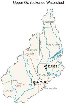
History of the Ochlockonee River WatershedThe Ochlockonee River originates in Worth County, Georgia, at an elevation of 420 feet. It winds 56 miles through the southwest Georgia counties of Colquitt, Mitchell, Grady, and Thomas before crossing into Florida and emptying into the Gulf of Mexico. The rich yellows and reds of the clay soil gives the river a yellow color. Old Spanish documents refer to this river sometimes as the Rio Agna.
What is a watershed partnership and why is it needed?The Ochlockonee River watershed has been identified as an impaired waterbody under Section 303 (d) of the Clean Water Act. Impaired streams are classified as not supporting their function due to fecal coliform bacteria and low dissolved oxygen.
Many people depend on the natural resources surrounding the Ochlockonee River for drinking water, hunting, fishing, and agriculture. These resources are extremely valuable for the local economy. A watershed partnership is comprised of private and public individuals, companies, and local, state, and federal agencies who work together to help conserve and restore the natural resources of a watershed. Partnerships bring together all entities interested in recovering and cleaning up the Ochlockonee River with a coordinated management plan for water quality, and fish and wildlife protection. |

